2D BLE is a major improvement over 1-dimensional (1D) modeling although some portions of the inputs remain similar. The major difference is that 1D methodologies are tied to a profile baseline and cross sections to determine risk while 2D BLE is not. The profile baseline is restricted to a drainage area of greater than 1 square mile and some semblance of a stream to collect water. The models show what happens when the water from a flooding event reaches the profile baseline (stream). This makes modeling for lakes difficult and does not represent overland flooding scenarios.
2D BLE is not confined to the profile baseline and cross sections. It instead takes a whole surface into account. This modeling uses 2D rain-on-grid made possible by HEC-RAS 6.0 software, which relies on a user defined mesh and high-resolution terrain data to capture the flow of runoff through an entire watershed. By using newly acquired LiDAR (2019, 2020, 2021) a more up-to-date picture of flood risk can be realized.
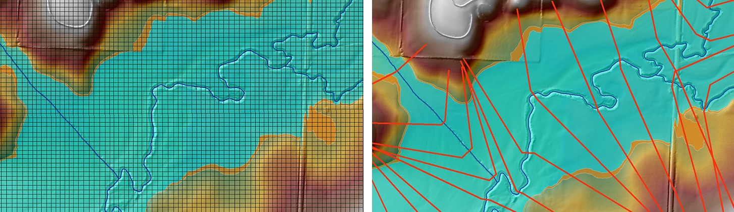
Figure 1. 1D mapping uses a profile baseline and cross sections on right. In areas of confluences this can make drawing appropriate cross sections difficult and can greatly influence the results of modeling. The grid produced by 2D mapping is shown on the left. This grid can be adjusted to be more resolute for areas of development to more accurately represent risk and eliminates the effect of poorly drawn or difficult to place cross sections on modeling results.
The result of taking the whole surface into account is a more comprehensive understanding of flood risk due to pluvial flooding (overland flooding not tied to streams) as well as fluvial (stream/river) flooding. In vast flat areas where there is not a defined stream there are paths the water follows that experience flash flooding. While not as costly as fluvial flooding that goes through cities (often located near rivers), pluvial flooding is nonetheless a risk for road access and emergency response related issues. This information can be used for stormwater management strategies by communities as well.
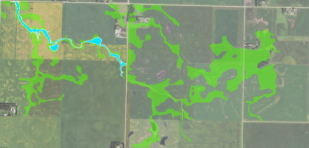
FIGURE 2. 1D MAPPING IS CONFINED TO AN ACTUAL STREAM BEING PRESENT ON THE SURFACE TO HELP DECIDE WHERE TO START MAPPING. THE BLUE SHADING SHOWS THE 1% ANNUAL CHANCE FLOOD RISK MODELED USING THE 1D APPROACH. 2D MAPPING, (GREEN SHADING), IS NOT CONFINED TO A STREAM BEING PRESENT TO HELP DECIDE WHERE TO START MAPPING. INSTEAD THE WHOLE SURFACE IS USED TO MAP FLOOD RISK IN AREAS OVER 1 SQUARE MILE.
The new risk data will benefit communities by providing more comprehensive understanding of the flood risk in areas under consideration for future development, both in cities and rural housing developments. Through smart planning and coordination, development can start or continue in an area with an eye to the future - risk can be planned for and mitigated. This information will be free to all of Iowa and can be used as best available data by jurisdictions, if they choose to use it for regulatory purposes. In cases where a jurisdiction decides it would like its regulatory mapping updated with the 2D BLE product Iowa DNR will work with them to help with that process. Risk data products listed below are developed as part of the 2D BLE process:
- Raster format data for analysis through GIS
- Water surface elevation (WSEL) grids for floodplain management/emergency response
- Potential for cumulative rise/change calculations during development planning
- Velocity grids for better understanding of flood risk
- Distance times velocity calculations for floodway determination
- Shear stress calculations for determining areas at risk for soil or bank scour