On this page...
Iowa is home to over 150 different fish species. Some may be familiar to you, walleye, largemouth bass, and bluegill, because they are sport fish - species that are abundant enough to support a fishery, large enough to bend a fishing rod, and aggressive enough to bite a hook.
There are many other species hidden beneath the water’s surface, some of them rare or difficult to find. Iowa DNR manages all of these species as part of the incredible aquatic resources Iowa is lucky to have.
Back to topHow to Identify Iowa Fish
List items for How to Identify Iowa Fish
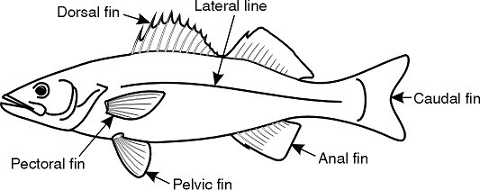
Fish often are described by characteristics of their body shape, mouth, fins, and even scales. Knowing key characteristics of different kinds of fish will help you identify them. Fish that look alike or have similar characteristics are grouped together.
Ten species of catfish live in Iowa waters. Catfish have rounded, scaleless bodies with flattened bellies. They are further distinguished from other groups by the eight barbells or “whiskers” around their mouths. Strong, sharp spines are located at the insertion of the dorsal and pectoral fins.
Some of the most popular sportfish species, such as basses, bluegill, and crappies are members of this family. Three black bass species live in Iowa waters and are longer-bodied with large, toothless mouths. They are aggressive predators, growing up to 10 pounds.
Often when people say “sunfish,” they are describing six different species of disc-shaped fish found in Iowa waters. They typically are small and generally are short and deep-bodied. All sunfish have at least one spine at the front part of the dorsal fin, which is never completely separated from the rear portion. Their body is deeply compressed laterally with pelvic fins nearly beneath the pectoral fins.
Two species of crappie are found in Iowa. They are not as deep-bodied as other members of the sunfish family, and are black and white. The lower jaw is longer than the upper, and they are “humped-backed.” Crappies seldom exceed two pounds.
Iowa’s popular gamefish, walleye, sauger and yellow perch, are some of the 20 members of the perch family in Iowa. The remaining members are various species of darters. Members of the perch family have rather slender, elongated bodies and a large bone on the gill cover that ends in a flat spine. The spiny and soft portions of the dorsal fin are completely separated.
The native brook trout and the naturalized rainbow and brown trout are the only coldwater gamefish in Iowa. Trout are covered by tiny scales, and their fins have no spines. They have an extra “adipose fin” on their back behind the dorsal fin, just in front of the tail.
Three pike family species live in Iowa: northern pike, muskellunge, and grass pickerel. Members of the pike family have long, cylindrical bodies with a short dorsal fin far back on their body. Their heads are flattened with duckbill-shaped jaws lined with very sharp teeth.
This is a very diverse family with 50 representatives in Iowa. Most are small, less than 12 inches long as adults. Native minnows are similar in appearance to suckers, but have fewer than 10 rays in the dorsal fin. Minnows have scaleless heads. Some very important invasive species, carp and goldfish, are also in the minnow family.
Once referred to as "sea basses", three members of this family are found in Iowa. White bass and yellow bass are native species, and the hybrid striped bass is an introduced species. This hybrid, a cross of a striped bass (Morone saxatilis) and a white bass, does not occur in nature and provides trophy fisheries thanks to fish culture and stocking. Temperate bass are different from black bass in their deeper bodies, laterally compressed shape, relatively small mouths, and the number of spines.
Sixteen species have been collected from Iowa waters, but several are listed as threatened or extirpated. Their characteristic mouth is on the underside of their head and surrounded by fleshy lips. Their head is scaleless, and their fins lack rays. Many suckers are often confused with minnow species, but they differ in many features. Most suckers have 10 or more dorsal fin rays, which is always one or two more than the native minnows. The pharyngeal tooth pattern is wholly different in the suckers.
Primitive fish in Iowa include paddlefish, bowfin, sturgeon, gar and lamprey. They lack one or several of the features more "advanced" fish species have, such as jaws, ganoid scale type, lack of vertebrae, body structure, or phylogenetic relations. They are all unique, with only a few fish species occurring in each family.
Iowa has several peculiar families with only one or two members. Some of the more common fish include the freshwater drum, brook stickleback, and gizzard shad. Mottled and slimy sculpins are found in the trout streams of northeast Iowa. American eel, mooneye, and burbot are only found in the largest of Iowa's rivers. Other unique Iowa fish include the central mudminnow, brook silverside, banded killifish, blackstripe topminnow and the trout-perch.
How to Fish For:
Back to topFish Conservation
Iowa DNR works to protect fish, fisheries, and the aquatic ecosystems upon which they depend, not only today but for future generations. This work is accomplished in many ways.
Back to topFish Habitat Enhancement
Iowa DNR Fisheries staff use many habitat enhancements on Iowa waters to improve your chance of catching fish and provide shelter for all kinds of fish. They build some enhancements on the dry or frozen lake bottom and place others from a boat in existing water. Each habitat enhancement has its own limits and benefits that are usually focused on a specific species, season or type of fishing. Common enhancements are tree piles, rock reefs and mounds, spawning attracting areas, stake beds, benched jetties, bank hides and others.
Where these enhancements are placed can vary widely. All depths and locations can offer benefits to many species during some time of the year. A site is chosen based on many factors such as the natural bottom contour, where fishing would be best to avoid conflicts with other activities, siltation, behavior patterns of the desired fish species, as well as any other concerns. Branches from brush piles are sometimes left exposed to help anglers find these submerged locations. Habitat structures placed in deeper water offer shelter during summer months, and structures placed in the deepest areas can provide excellent cover for winter panfish.
In streams, habitat enhancements include dozens of techniques such as longitudinal peaked stone toe protection, j-hook vanes, rock arch rapids, oxbows, riparian corridor restorations, and tree/shrub plantings. Every stream is different, but techniques emphasize incorporating natural materials, such as logs, stone, and live plantings. Oftentimes, stream habitat enhancements—and restorations in general—occur on private lands through partnership with the Iowa DNR.
Back to topLake Restoration
Lake restoration focused on essential water quality improvements is often paired with fish habitat projects through partnership and coordination. Iowans value clean water and desire safe, healthy lakes that offer many aesthetic, natural and recreational opportunities. Clean lakes improve the quality of life for Iowans and help bring economic growth to communities.
Since the Iowa DNR’s Lake Restoration Program’s inception, funding has been invested at 65 lakes, located across 47 counties. Major program accomplishments include:
- More than 26 miles of shoreline protection
- 5 Million cubic yards (~300,000 dump trucks) of excess sediment removed
- More than 14,000 acres of shallow lake and wetland enhancement
- More than 200 watershed improvement practices, such as upland habitat and stream restoration, sediment ponds, terraces, and grade stabilization structures to reduce nutrient and sediment pollution to downstream lakes
- 45 infrastructure projects, such as dam/spillway repairs, lake outlet water control structures, and fish barriers to prevent migration of fish species that negatively impact water quality (common carp)
- Increased water clarity at more than 70 percent of projects following restoration, with an average increase of 1.5 feet in water clarity
- Improved habitat for fish and other aquatic life
- Removal of several lakes from Iowa’s Impaired Waters List
Learn more about the Lake Restoration Program.
Back to topAquatic Plant Management
Healthy aquatic ecosystems have plants instead of algae. Native plant species, such as coontail, water celery, and many of the pondweeds, provide greater oxygen production for fish, shelter from predators, and habitat for the macroinvertebrates on which fish like Bluegill feed. Plants are important for some fish to lay their eggs, like yellow perch. A healthy fishery has plants over 20-40% of its surface area, usually in the littoral zone along the shoreline.
Aquatic plants can enhance fishing and the natural beauty of a lake, but may also become overgrown. Iowa DNR Fisheries has a dedicated Aquatic Plant Management Program to assist staff and partners with appropriate plant management plans and treatments, and balancing ecosystem needs with access for fishing and other recreational uses.
Back to topAquatic Invasive Species
Invasive and nuisance species can damage the native fish community, reduce fishing quality, and hurt the aquatic ecosystem. These species range from fish to plants to macroinvertebrates…even plankton. Because some invasive species are microscopic - such as zebra mussels and spiny waterflea - we encourage all boaters to Clean, Drain, and Dry every time.
Invasive plants, including curlyleaf pondweed and Eurasian Watermilfoil, can choke out native aquatic plants, consuming available space and resources for plant growth. These thick clusters of plants can die off mid-summer, rotting and leading to algal blooms, oxygen depletion, and fish kills.
Zebra mussels can colonize over native mussels like a layer of carpet, suffocating entire native mussel beds and blocking water supply pipes.
Fish species, including all species of carp and gizzard shad, can become so abundant in compromised waters that they take over 90 percent of the fish biomass. This often occurs because they are highly reproductive, highly tolerant of poor water quality or habitat, have no natural predators, and are very competitive at finding food.
Invasive species management strategies include prevention (Clean, Drain, and Dry!), reduction or control, and elimination. For example, watercraft inspectors work hard every summer to ensure that boaters are aware of the dangers of zebra mussels and the necessity for preventing invasive species transport across waterbodies.
Our Aquatic Plant Management Program works to eliminate early plant invasions if possible, and to reduce the known infestations through early treatment. Our Fisheries staff work to renovate entire fisheries when necessary, being forced to “reset” the fish community when an invasive species is out of control. These efforts are some of the most challenging that we face, but some of the most important because they affect the entire aquatic ecosystem.
Learn more about the Aquatic Invasive Species Program.
Back to topMonitoring of Species Status
Iowa DNR monitors fish, mussel, and crayfish species and regularly updates their status as threatened, endangered, or of other special concern. We call these Species of Greatest Conservation Need (SGCN). Some fish, like lake sturgeon, could provide unique fishing opportunities one day with adequate protections and careful, thoughtful management. Iowa’s SGCN fish species include:
- Chestnut Lamprey
- American Brook Lamprey
- Lake Sturgeon
- Pallid Sturgeon
- Pearl Dace
- Pugnose Shiner
- Blacknose Shiner
- Weed Shiner
- Topeka Shiner
- Black Redhorse
- Freckled Madtom
- Grass (Redfin) Pickerel
- Pirate Perch
- Burbot
- Western Sand Darter
- Bluntnose Darter
- Least Darter
- Orangethroat Darter
Iowa’s SGCN mussel species include:
- Slippershell
- Cylindrical Papershell
- Spectacle Case
- Purple Wartyback
- Butterfly (Mussel)
- Higgins’ Eye Pearlymussel
- Yellow Sandshell
- Creek Heelsplitter
- Bullhead (Mussel)
- Round Pigtoe
- Strange Floater
- Pistolgrip
- Ellipse
Back to top