Many of Iowa’s thousands of lakes, ponds, and reservoirs are stocked and managed by the Iowa DNR, offering abundant fishing, especially of panfish like crappie and Bluegill. Several are fishing destinations for Muskellunge (“muskie”), Northern Pike, and Walleye.
Back to topNatural Lakes
Iowa’s natural lakes, formed by glaciers, are most numerous in the northern half of the state. The most recent glaciation reached the central part of Iowa, creating a large, flat, nutrient-rich landscape called the Des Moines Lobe. This landscape features not only large natural lakes, such as Spirit Lake and Black Hawk Lake, but also shallower wetlands essential for migratory waterfowl, turtles, and amphibians. They are characteristic of the Prairie Pothole region that extends west into neighboring states.
Natural lakes tend to be more round in shape with gently sloping shorelines, abundant emergent and wetland plants, and smaller watersheds relative to their surface area. They may grow and shrink with wet and dry years, although some have been stabilized with water control structures.
Natural lake fisheries feature Walleye, Muskellunge, Northern Pike, Yellow Perch, Bluegill, and Yellow Bass. Spirit Lake and Storm Lake serve as two of the state’s key broodstock lakes for Walleye and Muskellunge, helping to support fish stocking in many other waterbodies.
Back to topPonds and Reservoirs
Ponds and reservoirs, formed by dams, are most numerous in the southern half of the state. When Iowa’s first fisheries professionals began working, they recognized the need for all Iowans to have good access to water-based recreation like fishing. They created a plan to establish a “lake” in every county, resulting in many of the state park lakes we enjoy today.
We tend to call smaller waters created by dams “ponds” and larger ones “reservoirs.” Many in-between may be called “lakes” but are not naturally formed like the glacial lakes were. They can often be recognized by their long, straight edge along one side, their spillway structure, and their more complex shoreline with longer tributary arms.
Ponds and reservoirs tend to have larger watersheds relative to their surface area because they catch water from a stream or river. They often receive sediment, nutrients, and other pollutants from upstream at a high rate, causing them to change quicker than a natural lake might. They may also have more rapidly-changing water levels as they absorb and hold back floods, making it difficult for healthy aquatic plant communities to grow.
Many pond and reservoir fisheries feature Largemouth Bass, Bluegill, Crappies, Walleye, Muskellunge, Hybrid Striped Bass, and Channel Catfish. Ponds may be stocked with Rainbow Trout thanks to the Trout fee-funded trout program, and many near where you live may be part of the Community Fishing Program. On the larger end, where water can be deeper and somewhat cooler, fish such as Walleye and Hybrid Striped Bass may be stocked. Rathbun Reservoir in southeastern Iowa serves as an essential broodstock source for Walleye stocked across Iowa.
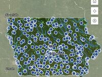
Browse hundreds of river accesses and county and state managed lake contours, miles of trout streams, over 2,000 fish structures, community fishing ponds, and Mississippi River Lock and Dam locations.
Lake and Reservoir Fishing Tips & Techniques
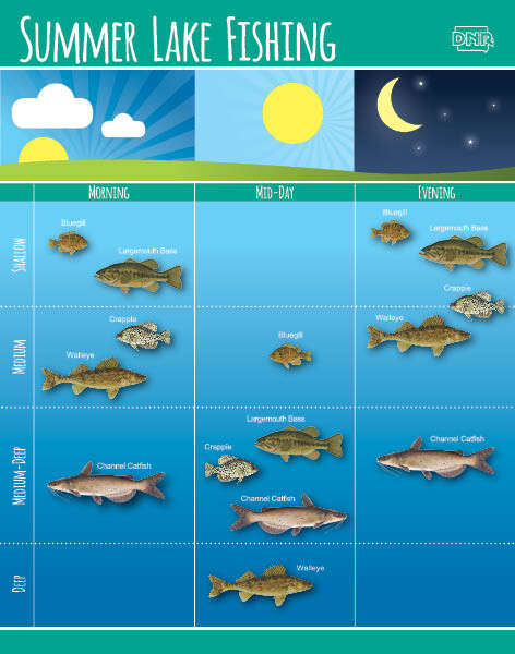
Fishing by Depth and Time
Fish tend to move throughout the day and seasons to find their preferred balance of temperature, oxygen, and feeding opportunities. Use this general guide to target different fish species throughout your fishing time.
Morning
Shallow: bluegill, largemouth bass
Medium: crappie, walleye
Medium-deep: channel catfish
Mid-day
Medium: bluegill
Medium-deep: largemouth bass, crappie, channel catfish
Deep: walleye
Evening
Shallow: bluegill, largemouth bass
Medium: crappie, walleye
Medium-deep: channel catfish
Back to top